A good day for a rest day as some of the days have been long and it has been very hot. I had a wander round the centre of the city then a coffee in the Markt to watch the people go by. I went back to my room with a large slice of watermelon for some rest and to do some washing. I was surprised how quiet the city centre was. A lot of the restaurants, bars and shops were shut but so were the tourist attractions.
Grote MarktGevangenpoort. Translated this means Prison Gate. Ironically it now hosts an escape roomGemeente (town hall)De Teerkamer strongly recommended
Most of the days now are about 15 miles long. This was decided mainly by the availability of accommodation but also by what I thought was a good distance to test out my leg. The hotel was excellent, breakfast was at least as good as the previous ones and so plentiful that I had to sit down for 20 minutes before I could hit the road,
The hotel was on the main road by the nature reserve so I had a short but pleasant walk through woodland and then a small residential estate to get to the town of Kalmthout. I stopped at a baker and got an enormous baguette stuffed with cheese, egg, salad and mayonnaise for 4.90€ that was delicious. Much nicer than the food from some of the chains in the UK. Support your independent outlets!
An alley next to the bakers led to a cycle path that headed east across farmland. The countryside was absolutely flat. There were no dykes to break up the fields, the view eventually being limited by lines of trees. Although I prefer the mountains, walking through this sort of countryside made a very relaxing change. It reminded me of the Lincolnshire fens where my brother-in-law farms.
Looking back to Kalmthout The cycle path to Achterbroek
Today there was an “event” going on. There were a lot of young children wearing neckerchiefs like scouts wear. There were play areas in the barns and adjacent fields. Trailers went up and down the track, being drawn by horses or tractors. It looked like a good time was being had by all. There were also a lot of cyclists but they looked that they were going shopping or to work rather than a leisure ride.
At the end of the track I went through a small village called Achterbroek.
Thatched cottage in Achterbroek
The tarmac track continued through more farmland. Eventually I crossed a main road and turned in a dirt track though the wood of Pastoorsbos. I don’t mind the flat countryside but I wish there was less tarmac. Unfortunately I was soon back on a road that skirted the village of Sterbos
Pastoorsbos
There was then another section on paths through woodland and farmland before I returned to tarmac to walk through the town of Wuustwezel. My mind idly thought whether this was some form of sausage made from a species of Mustelid.
As an aside, and more sensibly, I could not tell much difference between written Dutch and written Flemish. The few words I do know seemed to be the same. The Netherlands and Belgium were part of the same country until Belgian independence was recognised at the Treaty of London in 1839. (Germany were co-signatories to this treaty but conveniently ignored it when they invaded in 1914). I suspected Dutch and Flemish were closely related and according to Brittanica.com they are the same language.
I digress. Wuustwezel was a modern town with a busy road running through the middle of it. There was a bakers that did nice cake though (an essential feature of any town, city or village IMHO).
I took a cycle lane that led past the church into open farmland and turned on to a lane next to an open air bar they were just setting up (bother, 24 hours too early). This led to a path that went through woodland and open farmland all the way to the railway station just outside Brecht. Co-incidentally, I was staying in the converted old station in the middle of Brecht. I needed somewhere to eat and the owner recommended the Brasserie De Schandpaal which was good. If you are here in May or June you must sample the asparagus dishes which are excellent. The Belgian farmers keep the asparagus covered with soil so it stays white. And very tasty.
Fully refreshed from yesterday’s rest I set off for the Belgian border. It was another hot, sunny day.
Statue at railway station. Darth Vader does formula 1?
I crossed the railway line and set off through the residential area of east Bergen op Zoom. I turned into a park and walked alongside some ponds. It has been very dry here and so much water has evaporated from the ponds that they reminded me of the river Ankh from Discworld, the surface would probably have taken my weight.
The path went through a hospital car park and then into an underpass under the ring road. I was out of the city! I turned into a wood and after a few hundred metres I arrived at confluence of GR trails outside a youth hostel.
Spoilt for choice
I took great care to select the correct red and white striped waymark and set off deeper into the wood. I soon turned off the tarmac surface to follow a sandy path shared with horse riders. This wound through the trees before emerging at a wider trail. Some of the forest is private and some is a nature reserve so as well as the GR signs to keep me on the correct path most of the side branches had no entry signs on them.
Old stables in the Wouwse Plantage
The broad track continued for a couple of kilometres. I then emerged into farmland and finally on to a road that took me to the small border village of Vleet. I left the village on a farm track and crossed the Dutch/Belgian border, marked by a stone post placed in 1843.
Border post no. 243
Apart from the post the only border marker was a row of flagstones in the road. If that had been the case in “The Great Escape” Steve McQueen would have got away.
The border
The track zigzagged its way between Belgian fields. I took a slight detour to the village of Essen Hoek. I was now in Flanders, but well away from the area that saw the deaths of over a million soldiers in the First World War.
Approaching Essen Hoek
I left Essen Hoek on the road. After a few hundred metres I turned on to a farm track that took a zigzag route between fields. Most contained crops but in a few small herds of cows were grazing. After a kilometre or so there was a path diversion. The Cicerone guide had warned me there might be a diversion as in 2017 the farmer had grown maize across the path. In fact the new route was 3-4 kilometres longer. The new path turned west and re-crossed the border back into the Netherlands at post 248. It then skirted the edge of the town of Huijbergen on roads before turning south east and crossing back into Belgium. I turned on to a farm track that seemed to go on forever but eventually I reached a path that was the original GR5 route.
I now entered the nature reserve of Kalmthoutse Heide for the best walking of the day, through forest, across heathland, passing ponds with water birds or full of frogs. There was over 7km of fine walking with not an inch of tarmac in sight. Even better, when I got to the road at the end there was my hotel with a restaurant next door.
I was sad to leave De Marehoeve but I set off on my last day’s walk entirely in the Netherlands. Today was longer than it says in the book, partly because I stayed off route last night and partly because I took a detour later on to look at an old fort.
Windmill near De Marehoeve
I walked back to the canal and crossed it on a road bridge. I then skirted the edge of Nieuwe Vossameer, with a good view back to its church, to follow another road back to the canal by an old windmill and to rejoin GR5. It was already very hot.
Crossing the Schelde-Rijnkannal
There was no shade on the canal but it was a pleasant walk, although I was again walking on tarmac at the foot of a dyke.
Canalside walking
This time the breeze was blowing along the dyke helping me to keep relatively cool. After a few kilometres the path crossed the dyke and joined a road. I followed this to the next dyke where I joined a path that ran next to some trees giving me some shade.
The shade did not last long. At the next dyke junction I turned away from the trees into full sunshine until I reached a quiet road. I turned on to the road and a short while later I arrived in Halsteren which is really a suburb of Bergen op Zoom. I was now hot and thirsty. There was a garage on the main road so I bought some water and then set off through a residential area. I am all for birthday celebrations but I hope this one doesn’t catch on in the UK:
Happy Birthday to you
I can think of no redeeming feature. I saw two more of these in Bergen. At the end of the development I entered a wood. I was pleased to be back on a footpath and in the shade. Here I took a detour through the trees to the ruins of the Fortress De Roovere. There are only mounds remaining of the extensive fortifications here, and these do not photograph well (at least in my hands with an I-phone; there was a high tower that you could climb to get a better view but by now I was hot and tired). There were a lot of information panels, in English as well as Dutch telling me about the history.
Approaching Fortress De Roovere
From the 16th century, a series of extensive defensive Waterlines were built to protect the southern Netherlands from invasions from, successively, the Spanish, French and Belgians. The latest were built just prior to the Second World War. Once cannon had been developed, the medieval masonry castles were less effective as a defensive structure. At this time the Delta region was very marshy. Earthen banks, which were more resistant to cannon fire, were constructed joining bastions where cannon could be mounted to repel the invaders. In times of war, the area between the defences could be flooded, the bastions being built on land that would remain above the water. There was an artist’s impression of men pole vaulting across channels from dry land to dry land and it was easy to see how this would impede the progress of an invading army.
The entrance to Fortress De Roovere was across a “Moses Bridge” that crossed the moat below the waterline and could presumably be easily flooded if under attack. This has been restored.
The reconstructed Moses BridgeThe water level nearly reaches the top of the parapet of the bridge
This was well worth the detour. I now followed paths and a road through the forest to the outer ring road around Bergen op Zoom. One of my dislikes is having to walk though a lot of residential developments to get to the centre of a city. Today I was pleasantly surprised. I crossed the road and, after a short walk through a housing estate, I entered an area of parkland and woodland that took me to within a kilometre of the city centre. I then joined a cycle path that passed alongside another restored fort, part of the old waterline. From there it was just a short distance to my hotel.
Herkingen lies on the Grevelingenmeer which is a lake formed from the two dam systems across the Rijn and Maas rivers; separating the lake from the sea to the west and the inflow from the rivers to the east. These were built as part of the delta works. This caused havoc to the ecosystem of the estuary as the water trapped between the dams became brackish and almost all the fish died so sluices were built in the sea dam to partially restore tidal flow but so far there has only been limited recovery. The lake is a popular recreational area and Herkingen has a marina, from where I started my day’s walk.
Herkingen is protected by a dyke. There is a gap to access the marina with large watertight doors that can be closed to prevent flooding.
Spoiler alert! There never was a Dutch boy who put his finger in a dyke to stop a flood. It is not even a Dutch fairy tale, it is an American story by Mary Mapes Dodge. When a dyke fails a whole section collapses, there is not a small hole. However, in the 1953 flood some deaths and considerable damage to large cities such as The Hague and Rotterdam were prevented by a captain manoeuvring his ship into a 15 metre breach in a dyke which allowed the placement of sandbags to seal the gap.The most densely populated part of the central Holland, with more than 3 million inhabitants, was saved from flooding.
I climbed up to the top of the dyke and set off along the Meer on a concrete path It was hot again but there was a cooling breeze. I had taken more water with me today but I was grateful to be able to refill my bottles at a campsite after a few kilometres. The cycle path was at the base of the dyke. I cannot practice mindfulness walking on a cycle path, I tend to wander a bit and get urgent sounding bell rings from the cyclists as I deviate into the middle of the track. I did appreciate how much more popular cycling is in Holland compared to England. There were very few recreational walkers but a lot of cyclists. Small scooters were also allowed to use the paths and it was an easy and safe way for motorised wheelchair users to get fresh air.
Looking towards the Grevelingdam from the footpath on the top of the dyke
Two huge dams separate the body of water called the Krammer from the Grevelingenmeer. These dams, the Grevelingdam and Philipsdam are over 9km long. I dropped off the top of the dyke to join a cycle path across the Grevelingdam. There was plenty of bird life as I walked along. Sadly, there was also a small number of apparantly uninjured dead birds next to the lake so it looks like bird flu is still prevalent.
Halfway across the Philipsdam there were sluice gates to control the amount of salt water allowed upstream and two huge locks, each of which could accommodate four of the enormous barges at once, two side by side.
One barge was called “Bacchus” so I assumed it was full of beer. I later saw other barges with similar superstructure and I think they contain liquefied gas. Others had multiple container units on board, stacked two high, I counted 16 on one barge.
As you will have seen, another feature of the dams was the presence of multiple wind turbines. I know there is a lot of opposition to on shore wind farms in the UK but they were not particularly noisy and they produce clean energy. In this sting they are not even particularly ugly. However, I would be very upset if they adorned every hill in the Peak District so I guess I am a NIMBY as well.
After the dams the cycle path joined a small road. I was expecting to find a path to take me through an area of wetland called the Slikken but either I missed the path or, more likely as the red and white waymarks continued, the trail has been diverted. Eventually I reached the Schelde-Rijnkannal and it was a relief to get of tarmac and on to a path.
Schelde-Rijnkannal approaching Vossameer
By now I was hot and running out of water. I rejoined a road. GR5 goes into Nieuwe-Vossameer but I was unable to find accommodation there and had to detour to Oud-Vossameer. At the turn there was a farmhouse with drinks and an honesty box. I was very grateful for some water.
I arrived at DeMarehoeve to be greeted by Wilma and a really nice sugar and cinnamon cake. Another fantastic B and B. A large room with a good shower and a patio area. Most importantly, a large TV on which to watch the Champion League final.
I was tired and really didn’t want to walk into the village to find some food. “Do not worry, there is a take away that delivers” said Wilma. So pizza and football it was. In the morning I had another large Dutch breakfast. “Please make yourself some sandwiches to take on your walk” said Wilma, bringing me some bags to put them in. Another fine example of Dutch hospitality.
When planning today’s walk, on a cold March afternoon I thought it would be a good idea to combine two short stages into one long one. When I came to walk the double stage on the hottest day of the year so far (30 degrees C) it did not seem so clever!
There was a fresh food market opposite the hotel and I was tempted by the pastries from the baker’s stall but I decided they would just fragment in the rucksack. I walked through Rockanje, which is a small modern town, to get back to GR5. About 1km down a quiet lane I turned on to a footpath passing through sand dunes, the Voornes Duin, to reach a beach on the North Sea. This was a lovely beach with soft sand mixed with thousands of shells. The tide was out so I was able to walk on firmer sand close to the sea.
Voornes Duin
After a kilometre I approached the Haringvlietdam, one of the major components of the Delta Works.
The beach and Haringvlietdam
I left the North Sea beach to pass under the motorway to reach another beach on the Harinvliet. This is now a large fresh water lake, it used to be a salt water estuary. There was a bar by the beach. It was now quite hot and I wished I had chosen a shorter day so I could sunbathe and wander into Goedereede late in the afternoon. However, I had a long way to go so I set off on a cycle path across the dam.
I love transliterating other country’s signage. I know it’s probably politically incorrect but….. no happy free range chickens could be seen
The dam is 2.5km long. On the way you pass 17 sluice gates (they are numbered), each about 50m wide. There have been environmental concerns about the loss of the salt water habitat above the dam. In the Cicerone guide, Dorgan comments that the Dutch government were considering opening some of the gates to allow tidal mixing. One gate was open today.
Lakeside beach and damOne of the sluice gates
It was hot but there was a cooling breeze on the dam. I now set off along a cycle path through polder and no wind. I passed a small lake and then took a path through scrubland to reach the small, canal side village of Havenhoofd. Translated to English this means pier or jetty. There is a statue of a fisherman by the canal so I assume this was was a fishing village before the dams were built.
I continued down the canal some shade was offered by trees lining the canal. Goedereede is a small town that lies next to the canal. I took the chance to have a quick lunch in a small pub.
Goedereede Markt
It was another hot day. I had two miles of road walking through farmland with very little breeze. After a while the unchanging scenery began to get boring, even Carol Dorgan describes this section as monotonous. With the countryside being so flat it seems to take an age to get anywhere.
Heading for the tree lined dyke in the distance
When I arrived at the dyke it became clear that there was a footpath that ran along the top. It was good not to be walking on tarmac and there was also a breeze. For the first few miles the grass had been cut and walking was easy but eventually there were grass cuttings on top of the dyke and progress was hard work. I tried dropping to the side of the dyke but I still had to high step over the cuttings. Eventually I decided to cut across a farm lane to a road which I followed into Herkingen.
The name of my B & B for the night was “GR5.” It turns out the owner is a good friend of Carroll Dorgan, the author of the guide and helped him write the Dutch section. There is a photograph of him walking on a dyke in the book.
I was met at the gate by a wiry daschund. After barking at me to let me know who was the boss he kept me company for the rest of the evening. The owner (sorry, once again I have forgotten his name) brought me a beer. He was surprised I had done two stages on such a hot day. I have seen plenty of cyclists with big panniers on their bikes who are presumably touring but no backpackers. I asked my host and he told me he sees about 250 people a year doing the Northern GR5.
I am the boss in this garden
t was late by the time I arrived. “ Have you eaten?” He asked. When I said I had not he offered to bring me food that was left from his tea. I was too tired to go out and I gratefully accepted. Within a few minutes a plate of vegeburgers (home made) chicken strips, fried potato, yoghourt, a feta salad and bread arrived. Delicious! Then chocolate mousse to follow.
The accommodation was good too. I had a wooden outbuilding (much nicer than it sounds) with two beds, a shower and washroom and a garden, where I ate my tea, accompanied by the dog.
Breakfast was good too. The Dutch version of continental breakfast is not what you get in a UK hotel. Breads, cheeses, meats, hard boiled egg, orange juice, fruit. There was too much to eat. Then when I offered to pay for my supper he just said “us walkers have to stick together” if you are walking or cycling though this part of Holland go stay.
I was staying in the old part of Maassluis, by one of the main canals. For the next few days I will be walking through the Delta region of Holland, originally formed by the Rijn (Rhine), Maas (Meuse) and Scheld. The geography has become more complicated by the construction of multiple canals. My first task today was to cross the Nieuwe Waterweg but there are no bridges below Rotterdam so I allowed myself to use a ferry.
Maassluis old town (Huis Ann de Sluis is behind the trees on the left)
I left the B and B and followed the canal, climbing up the side of the lock in the above image. I walked around the Haven which, as it’s name suggests, is a harbour. There was a large barge, which appeared to be empty except for two cars on the back, leaving the Haven and two road bridges were elevated to let it pass. I did not see what they did with the railway bridge, presumably that can be raised as well.
The HavenThe barge, not the canal bank. Most of the barges had a car on the back
I walked past a post showing the height of previous floods.
There was a devastating flood in 1953 when over 1000 people died. To prevent this happening again, the Dutch government commissioned the construction of multiple dams, sluices, barriers and other defences across the river delta, called the Delta Works, some of which I will pass on the walk. I got on the Rozenburg ferry and crossed the Waterweg (free) and I climbed up on to the top of a dyke and walked west overlooking the Waterweg.
After about 400 metres I dropped off the Dyke and entered some woodland. This took me to the edge of Rozenberg. I walked through a residential area and then followed a cycle path to the top of another dyke. I followed the Calandkanaal to a road bridge. Across the canal I could see the enormous Europoort.
The next 2km involved crossing three bridges, on cycle paths so I was separate from the road. While not classical country walking it was interesting to see the size of the ports and the cargo ships. I crossed the Candalbrug, the centre of which can be raised vertically to allow tall ships to pass through. On the south side of the bridge there was a long row of tall half cylinders, definitely not containers. I cannot guess what they are for. To absorb traffic sound maybe? Two more bridges took me across the Hartelkanaal and Brielse Meer.
Candalbrug
Brielse Meer used to be a branch of the Meuse river. This was dammed as part of the Delta Works and is now a lake about 10km long. The cycle path dropped down to the south edge of the Meer and I followed it to Brielle. Most of the walk was on tarmac but I took a few detours through trees, alongside little streams or ponds. There were several swans shepherding their cygnets through the water. On the Meer I could see small pleasure craft. To the south there were the agricultural fields of the polder.
Brielse Meer
As well as the GR series of paths, there are ultra-long distance routes as well. For example, GR5 forms part of the E2 path which will eventually start in Galway, cross Ireland. After a ferry to Stranraer it will pass through England before taking a third ferry to Ostend. It then links up to GR5 to eventually arrive at the Mediterranean. On the way to Brielle I saw a sign for E9 which runs from Biskaje in France to Gdańsk. I decided to give it a miss.
The church tower of Brielle came into view and I soon arrived at the small town. Brielle was a fortified town, surrounded by a canal, like a moat. Almost all of the fortifications have disappeared but mounds of earth are still clearly visible. I spent an hour wandering through the narrow streets before arriving at the Markt where I stopped at the old guardhouse which is now a cafe.
Brielle is famous in Dutch history for the actions of the “Sea Beggars.” These were men who had been expelled by the Spanish rulers, who were becoming more oppressive in combatting both religious and political opposition. The Sea Beggars sought refuge in England but eventually Elizabeth expelled them too. After leaving England they invaded Brielle on 1 April 1572 and took it from the Spanish. This encouraged other Dutch opposition to rise and eventually independence from Spain was achieved.
After a “light” lunch of smoked salmon (about half a fish) cream cheese , dill mayonnaise, lots of salad and bread I managed to start walking again with difficulty. I tried to find the plaque commemorating the Sea Beggars but the signs took me to the remaining bastion on the city walls. Time was getting on so I followed the canal cum moat back to GR5.
As well as the GR series of paths, there are ultra- long distance routes as well. For example, GR5 forms part of the E2 path which will eventually start in Galway, crossing to Stranraer then passing through England before arriving in Ostend. As I arrived at Brielle I saw a sign for E9 which runs from Biskaje in France to Gdańsk. I decided to give it a miss.
I left Brielle to continue my walk along Brielse Meer on cycle tracks and footpaths, mainly on the top of a dyke. I could see the church tower of Brielle across polder fields. About 3km outside Brielle I came to a tower called Stenen Baak. This was the first stone lighthouse in Holland, built in 1630, to replace older, wooden structures that had burnt down. Later it assumed a military role as well.
Looking across the polder to BrielleStenen Baak
I followed a cycle path for a short distance and then turned on to a path running through woodland. Things then became surreal with a plethora of gnomes, smurfs, rabbits, horses and other garden ornaments lining the path. Eventually I emerged inthe centre of a chalet park, so either they were placed by an eccentric, or, more likely, they are designed to encourage small children to go for a walk to see what they can find.
If you go down to the woods today…….
After another cycle path I entered the nature reserves of Tenellaplas and Voornes Duin. The path wound its way between trees, clearings where there was scrubland and ponds for about 6km. This was one of the best bits of the day. I emerged from the woods to join a road and walk the last 2km into Rockanje. While my accommodation (and food) was very nice I had to walk to the north side of the town and then retrace my steps back the following morning.
I have a new mascot this year. Lucy got it for me. She won’t know until she reads this but she has been appointed typo checker; an onerous role that has no reward but my eternal gratitude
Gundobear
A calm crossing so I should have slept better but I was over full with food and beer (only half a litre). Then, when I was fast asleep, the tannoy woke me up at 6:30 to tell me that breakfast was being served. I got dressed, had breakfast and went outside to see we had just entered the Nieuwe Waterweg (new canal). This is not so new, it was completed in 1872. The Rhine and the Meuse were silting up and none of the channels in the delta were deep enough for the large ocean going ships being developed to sail up to Rotterdam. As this was an important source of income, the Dutch monarch commissioned a new canal to be dug from Rotterdam to the North Sea to maintain the viability Rotterdam port. It certainly works! The canal was line with cranes and ports as far as I could see. The canal needs constant dredging and there are moves to deepen it further from the 16 metres it is today. The canal is lined by wind turbines. The Cicerone guide states that in 2017, 60% of the Netherland’s power requirement was supplied by renewables.
Looking back along the Nieuwe Waterweg
There used to be a signpost between the metro station and the ferry dock that marked the start of GR5 and pointed to Nice. It was taken down when the area was redeveloped and the new sign just indicates Bergen op Zoom, where GR5 crosses the border to enter Belgium.
The Cicerone guide suggests that one might want to dip a toe in the North Sea, so of course I had to do it, but this added 4 miles on to an already long day. I walked out to the shore through a park and across the dunes.
I walked back along the canal front. There were a few sculptures, including one to the Dutch and British governments for their role in participating in the Kinder Transport, rescuing Jewish children from the Nazis in the 1930s. I can’t see Stella or Rishi getting one for their role in the current refugee crisis.
There were also several remnants of defensive structures. Most were built in the 20th century but this has been an important strategic area since the dispute between Holland and Spain in the 16th century.
Hook van Holland was a sandbank on the Meuse until they started to build the canal. Initially it was built to house the construction workers but it grew into a resort in the early 20th century.
I finally set off on the actual route and I soon entered a park and walked through areas of pretty, deciduous woodland. In a clearing, there was some exercise equipment, I was not tempted. There were several sports facilities in the park. At one point there were several trees that looked dead but were covered in spiders webs. Larvae were trapped in some descending fibres. I was not sure whether they were trapped for food or whether they were spider larvae trying to attach themselves to passers by (animal or human) to start a new colony elsewhere.
After a short road section I re-entered woodland. This was the best part of the day’s walk, the path wound delightfully between the trees. There were ponds at intervals, some with bird hides. I heard the first pond before I saw it. It was surrounded by reeds and there must have been a colony of frogs as there was a cacophony of croaking. Scattered through the trees were concrete bunkers, apparantly left by the Germans in World War II, that are now bat sanctuaries.
When the path passed close to the edge of the wood I could see miles if glasshouses that seemed to be mainly for the growth of tomatoes. This is an important agricultural area and I saw many such farms over the course of the day.
After the wood GR5 followed a road for about 400 metres. Although it meant walking on tarmac, there was a cycle path to follow, properly separated from the traffic (unlike the UK). There was then a long section on cycle tracks and quiet roads along the line of the Oranjedijk, past more glasshouses and fields. This is polder country, reclaimed from the sea. It reminded me of the fens, the fields being separated by ditches. It was not particularly interesting walking and I was pleased to arrive at a small lake. While the lake was quite nice it was not quiet as it is a popular place for the Maassluis youth to cycle to to chill and listen to music.
I now followed cycle paths and quiet roads around the north west perimeter of Maassluis. I then had to follow field paths across polder fields. The town of Maasland looked quite close but the path meandered to cross ditches at bridges that seemed to be randomly placed. Cows grazed in most of the fields. These beasts were placid, unlike their brethren in the north east of Scotland, and mostly ignored me.
Crossing the polder near Maasland
I arrived in Maasland which has a very attractive centre, set between canals. It was then a short walk along the Nordvliet canal into the old centre of Maassluis.
Maassland
I stayed at the aptly names “Huis on the Schluis,” it faces the canal. An amazing B and B, I had a bedroom, sitting room and kitchen as well as a small garden. Breakfast was good too. After a good night’s sleep I was ready for the next walk.
Summer has arrived and it is time to set off on a walk. I haven’t done much walking this winter and I have had to give up skiing due to a knee injury and a prolapsed disc which caused sciatica. Fortunately most of my symptoms have settled with physio and training (thanks Conor) but I thought I needed something gentle to test my fitness. I have considered doing GR5 for a long time. This is a long distance path that stretches from the Hoek van Holland to Nice (most blogs only describe the alpine section that runs from Geneva to Nice). Over 1400 miles long, it passes through the Netherlands, Belgium, Luxembourg, Switzerland and France. Many years ago I walked part of the Alpine section, from Modane to St Etienne de Tinee as well as the stretch that coincides with the western part of the Tour Du Mont Blanc.
The northern section runs from Hook of Holland to Nyon, on the north shore of Lake Geneva. For someone who is rehabilitating, the first section, through the Netherlands and Belgium, is flat, I do not think I will cross a single contour line between Hoek van Holland and Maastricht, where I will take a break. If all goes well I will have to decide whether to continue through Benelux (rather flat apart from the Ardennes); skip a section and walk the more interesting Vosges mountains later in the summer or take on a more challenging Alpine trek. Other bloggers say the northern half gets very repetitive and I may decide to concentrate on more interesting areas. Also, accommodation is difficult to come by in the Lorraine area of France.
So the next two and a half weeks walking should be fairly easy. Much of the route through the Netherlands is below sea level, alongside dykes; called the Polder. The Belgian section runs mainly through forest or crosses heathland. On the last day I will cross back into the Netherlands to reach Maastricht. I do not think the walk will be challenging but most days end in villages that sound nice and I will pass through towns that have some historic interest. Of courser, the Belgians are famous for their beer so the evenings promise to be good. Very different from the last few walks that I have done.
The first stage was a trip to London to meet up with my sister and my daughter (and their significant others). I then got the boat train to take the overnight ferry from Harwich to the Hoek van Holland.
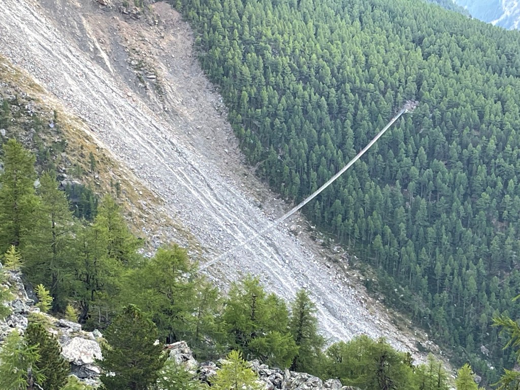
The final day. This section of the Europaweg was open and there were fine views of the mountains almost all day.
One of the highlights of the day was at the beginning. There was a steep 200 metre descent to the Charles Kuonen bridge. This claims to be the longest pedestrian suspension bridge in the world and was opened in 2013 after the previous, shorter, bridge was destroyed in a rockfall.
It is much less scary than it looks and didn’t swing or sway at all (there was no wind). It was an exhilarating experience, a bit like a theme park ride.
After the bridge I re-entered the wood and the path began to climb again, regaining the height I lost earlier. There were a lot of small flags that were marking the path that looked temporary. I wondered whether here were placed for a race. The ultramarathon race of Monta Rosa was due to start on 31 August so maybe they were placed for that.
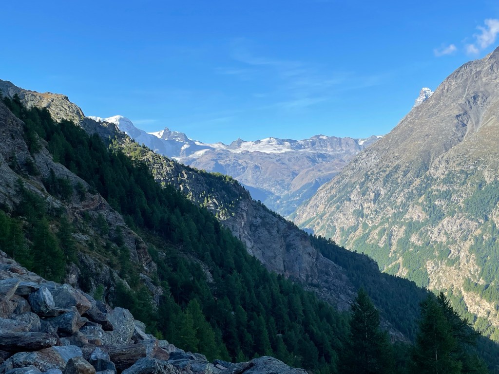
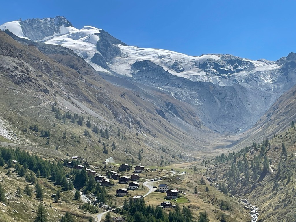
Finally, I emerged from the forest and got my first view of the Matterhorn peeping round the side of the valley.
First view of the Matterhorn (on the right) with the other peaks above Zermatt
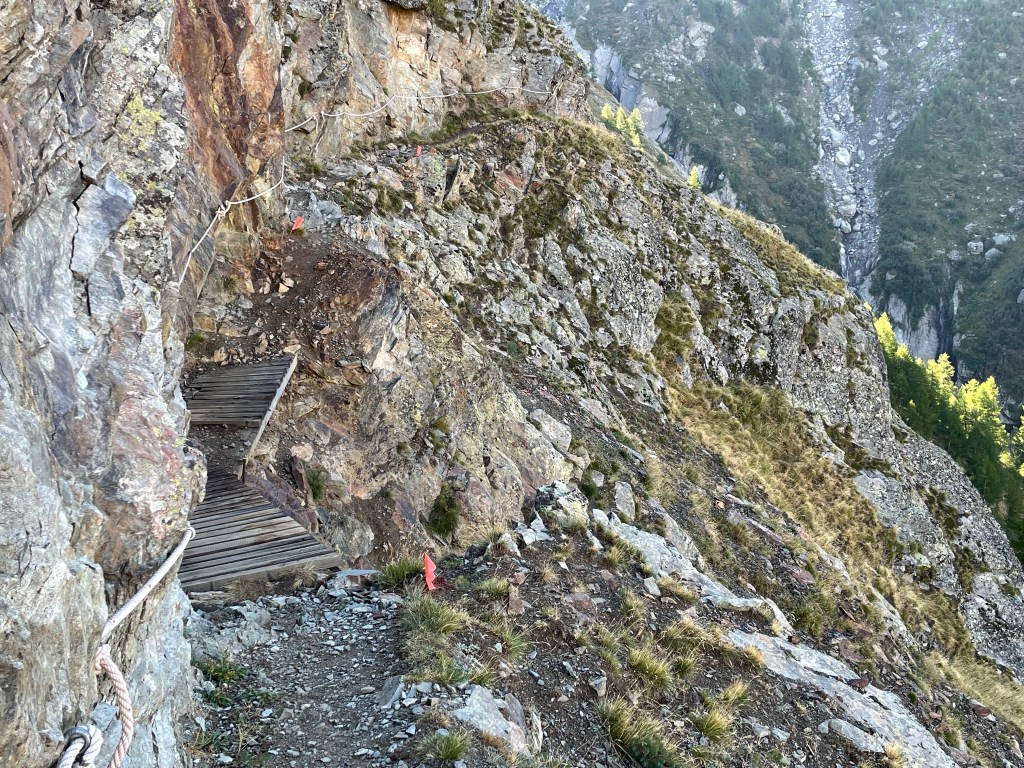
Now the path ran alongside the mountainside with superb views. There was a long exposed section, protected by ropes. In places there had been small rockfalls and the path had been replaced by short wooden bridges
On the Europaweg. The flag markers can be seen to the right of the path
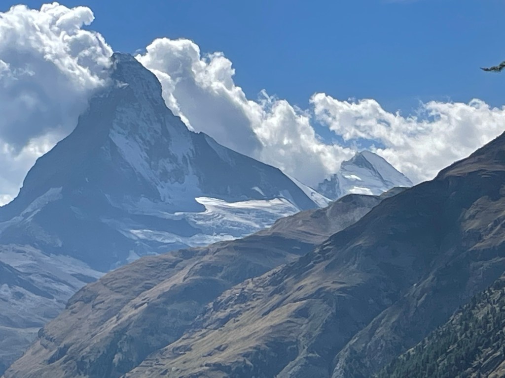
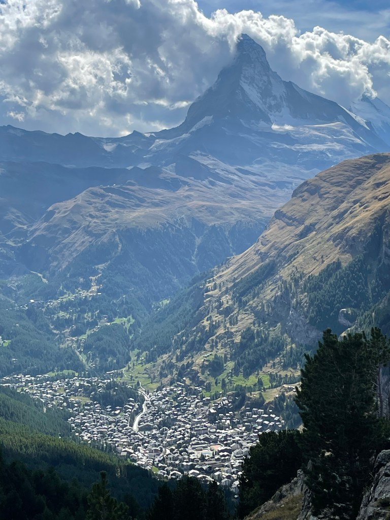
This was a fitting climax to the trek. I could see along the valley to Zermatt with its ski area beyond it. As the Matterhorn emerged from behind the valley wall it dominated the other peaks. The ridge on the horizon marks the Swiss/Italian border. In winter there are pistes across it and you can cross an international border for lunch.
The Europaweg then had to descend to avoid a cliff and scree slope and I lost about 300 metres in height. I re-entered the forest and there was a tunnel, protecting the walker from rockfall. After the tunnel there were several concrete shelves to deflect falling boulders. At one point the reinforced concrete had been broken and a large split boulder lay just below the path.
The path climbed up through forest to turn a corner and enter the valley formed by the Taschbach torrent. This led to the hamlet of Taschalp. Above the chalets are another collection of 4000 metre peaks
Taschalp
I stopped at a hut in the village for lunch, fresh salad rather than the stale pumpernickel and sweaty cheese that I had been carrying for several days. I then crossed the Taschbach and turned west to rejoin the Mattertal.
The path continued up the valley, above the tree line and the Matterhorn and its glacier came into full view.
Now there was another exposed section of path. At the end of this section there was a warning sign to proceed quickly because of the risk of rockfall. There were shelters made of corrugated iron in case evasive action was necessary.
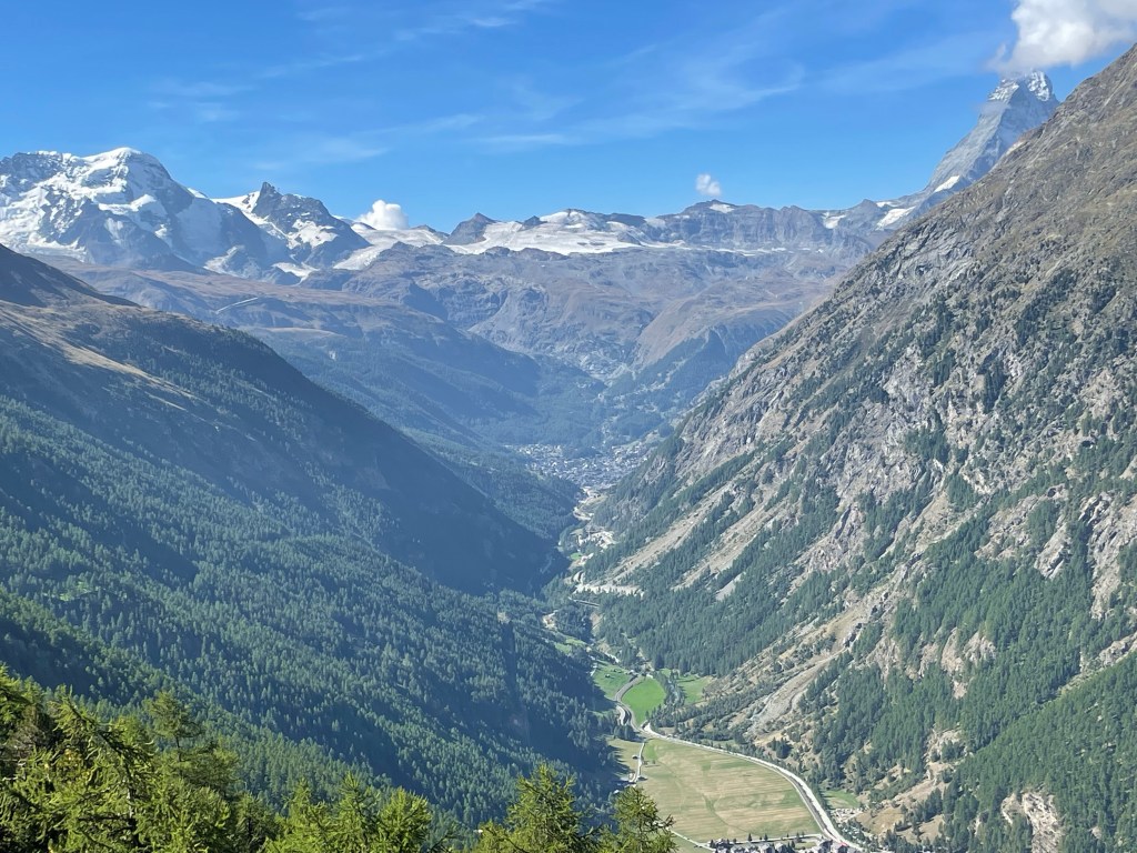
Finally I entered the Zermatt ski area with the town of Zermatt in the valley below
I now had a choice to make. I think I should have continued to stay high for more views and walk to the Sunnega underground funicular railway. Instead I felt I should walk into Zermatt. Initially the path descended steeply alongside a piste and through woodland. I then had a long, boring road to follow down into the town. My lodging for tonight was in Tasch so I took the Zermatt shuttle and said goodbye to the Mountains.
Kleinematterhorn from Tasch
This was a tough but rewarding walk. The way marking was excellent although there are a couple of sections that might be difficult to follow in poor visibility. My training was interrupted due to my knee injury and I noticed this on the first few days, at one point I thought I would have to abandon the trek. I did have intermittent muscular pain throughout the walk and this is something I need to address before next year’s adventures.
If you want to do this walk, be aware you need to be fit, some of the climbs are steep and prolonged. The exposure on the Europaweg can be avoided by following the valley, although you would miss the last section which was particularly good. The Pas du Chevres cannot be avoided, except by crossing another pass that is said to be a steep and potentially unstable boulder and scree field, it certainly did not look inviting. All the groups I saw took the Pas Du Chevres.
If you think it is for you, I recommend Kev Reynold’s Cicerone guide. If you have not walked in the Alps before then the Tour du Mont Blanc is also a great walk and may be a better introduction to Alpine trekking. Mountain walking is not risk free and it is up to the individual to decide whether the risks are justifiable.
Any factual information is taken from the Cicerone guide, local tourist web sites or information boards placed alongside the path.